
Vacant Land & Lot Photography in Chicagoland.
A land listing has no kitchen to sell it with. What a buyer needs is the shape of the parcel, where it touches the road, what adjoins it and what the ground actually does — and none of that can be photographed standing on it. Aerial coverage is the product here, not an add-on.
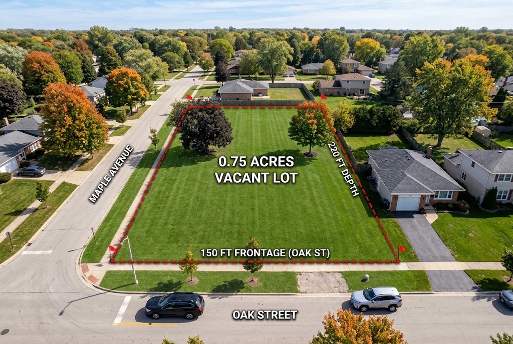
What a land buyer is actually trying to work out.
Where does it start and stop
A parcel has no walls. An overhead frame with the boundary traced against the road, the treeline and the neighbours is the one image that answers it.
How do I get onto it
Frontage, the culvert or curb cut, the easement, how far the drive would have to run. Access is the first thing that kills a deal.
What does the ground do
Low corners that hold water, the grade, the tree cover, what is already cleared. Oblique angles in raking light read topography that a top-down frame flattens.
Every parcel, readable from the air.
Boundaries, access and terrain in frames a fence line can't show.
- Aerial stills of the full parcel
- Boundary-line context angles
- Road and access frames
- Optional aerial video
- Photos back in under 24 hours
Pick the parcel package. Pick the date.
Set the acreage and the price is exact, with nobody to call first. Buildings on the parcel are fine; barns, outbuildings and a farmhouse get a couple of drone frames included at no extra cost.
Asked before every booking.
How much does vacant land photography cost?
A lot up to 5 acres is $195, a parcel from 5 to 50 acres is $325, and tracts over 50 acres start at $595 with aerial video included. Every tier covers the aerials, ground-level frames and a property line overlay. Land is quoted on the phone rather than through the calculator, because acreage and the number of parcels move the price more than anything a slider could ask.
Can you draw the property lines on the photos?
Yes, and it is included on every tier. The lines are traced from county parcel data or the plat you supply, which is accurate enough to orient a buyer on what is being sold. It is an illustration rather than a survey, and it is captioned that way on the delivered files.
What time of year should land be photographed?
It depends what the buyer is evaluating. Bare-tree months from November to March reveal contours, boundaries and drainage, which is what someone assessing buildability wants. Full canopy from May to October shows privacy and screening, which is what someone picturing a house there wants. Both are worth shooting on a parcel that will be listed a while.
Do you need FAA authorisation to fly over a parcel?
Only where the land sits inside controlled airspace, which is a real consideration for parcels near an airport. Authorisation is usually granted quickly through LAANC, and it gets checked before the shoot is scheduled rather than discovered on the day. Send the PIN or address and it takes a minute to confirm.